High resolution airborne geophysical surveys, worldwide, since 1956.
Sander Geophysics Limited (SGL) provides worldwide airborne geophysical surveys for petroleum and mineral exploration, and geological and environmental mapping. Services include high resolution airborne gravity, magnetic, electromagnetic, and radiometric surveys, using fixed wing aircraft and helicopters.
EST. 1956BASE OTTAWA, CANADAFLEET 12 AIRCRAFTSTAFF 160+ FULL TIMEFLOWN 15M+ LINE KM
THE SURVEY, DRAWN AS IT FLIESFLIGHT LINES PARALLEL, EVENLY SPACEDPRODUCT THE MEASURED GRID
The company
One company: aircraft, instruments, processing, interpretation.
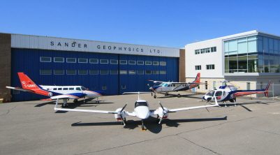
SGL head office and hangar, Ottawa, Canada. Photo: SGL.
SGL was founded in 1956 to provide ground geophysical surveys; airborne surveys began in 1958 and have been the main focus since 1967. The head office and aircraft maintenance hangar are located at the international airport in Ottawa, and the company has operated on every continent, including Antarctica.
Facilities at head office include a state of the art data processing department with an integrated digital cartographic department, a fully equipped electronics workshop for research, development and production of geophysical instruments, and a Transport Canada Approved Maintenance Organization for fixed wing aircraft and helicopters.
SGL specializes in surveys using one or more of the following methods, performed with specially modified fixed wing aircraft or helicopters. A digital elevation model derived from SGL scanning LiDAR, or a combination of radar and laser profiler data, is a standard product on all surveys.
Gravity
Gravity (AIRGrav)
Airborne gravity with AIRGrav, the only purpose-built airborne gravimeter currently flying commercial surveys, designed for the airborne environment and flown in an efficient light aircraft during normal daytime conditions.
150,000 hours of survey flying. No aircraft accidents or serious injuries.
SGL has flown and compiled more than 15 million line kilometres of high resolution airborne geophysical data since 1956, all of it with no aircraft accidents or serious injuries. SGL is a founding and accredited member of the International Airborne Geophysics Safety Association (IAGSA).
High resolution survey over various parts of Nova Scotia
Sander Geophysics has been selected to fly a magnetic gradient and radiometric airborne geophysical survey over extensive parts of Nova Scotia. Survey flying has commenced in eastern Cape Breton.
June 2026
Flying completed for the major project in Ireland
SGL has completed the last flight collecting magnetic, electromagnetic and natural radioactivity data for this extensive project, which began in 2011 and provides detailed geophysical data for the whole country.
January 2026
Airborne geophysical survey in Guinea, West Africa
SGL has been selected to fly an airborne geophysical survey in the eastern part of Guinea, launched at an official ceremony in Conakry under the World Bank supported geoscience program.